A number of videos are presented to disseminate important knowledge obtained in connection with various research and consultancy projects in Greenland. The videos tell quite different stories, but have a common angle related to the possibilities and need for adaptation to the future, including climate change, which, among other things, was in highlighted in a Arctic Council report focusing on West Greenland and Canada. The videos are recorded under "fieldwork of opportunity" for current fieldwork or other relevant activities in the field seasons 2020-2021.
The videos include the dissemination of projects within the areas of environmental monitoring of mining projects, oil pollution, climate adaptation and management in relation to e.g. birds and marine mammals in Greenland as well as permafrost, geological mapping, etc. More details can be found next to the individual videos.
The production of the videos is financed by the Danish Environmental Agency's “Miljøstøtte til Arktis” ("Environmental support for the Arctic"). The various research and consultancy projects also have different sources of funding.
Today, more than 80% of marine litter is plastic, and in fact our oceans contain more than 150 million tons of plastic. But what is the situation in Greenland? In this video, researchers from Aarhus University, DCE, inform about a monitoring project investigating trends in the amounts and types of marine plastic litter in Greenland. Different indicators are used, and this video tells about the use of beach litter and plastic in the stomachs of the seabird northern fulmar.
In the Vaigat Strait in West Greenland, landslides are frequent, and they can give rise to tsunamis when they hit the sea, which most recently happened in the area in 1952, 2000 and 2021. Many large landslides in the mountains have been mapped in the past, but the latest landslide mapping shows that there are huge landslides in the mountains along the strait and associated landslide deposits at the bottom of Vaigat.
In this video, we follow a team of researchers from the National Geological Surveys of Denmark and Greenland (GEUS), who drill cores out of the lakes around Saqqaq to find traces of the tsunamis that the giant landslides must have created. Sediments from the tsunamis may be hidden at the bottom of the lakes, and the dating of the tsunami deposits from the lakes shows that they occurred 7200-7600 years ago and had flushing heights of at least 45 meters.
The Technical University of Denmark (DTU) is establishing a series of boreholes on a transect from Sisimiut to Kangerlussuaq in West Greenland. The boreholes will be used to monitor bedrock temperatures and the change in thermal state of permafrost in the region. The transect is located in the widest non-glaciated area of West Greenland, and covers a climatic gradient from the relatively warm coastal climate with high precipitation at Sisimiut, to the dry continental climate at Kangerlussuaq with relatively warm summers and cold winters, over a distance of 160 km. Permafrost in the region is disappearing due to the on-going climate warming, and the boreholes will contribute to the understanding of current and future permafrost distribution, and the modelling of how the changing permafrost impacts e.g. rock slope stability.
The boreholes are established in collaboration with the Greenland School of Minerals and petroleum (KTI) in Sisimiut, and the work is integrated in the educational activities at both institutions (KTI and DTU).
Since 2007, The National Geological Survey of Denmark and Greenland (GEUS) has had an extensive network of automatic weather stations on Greenland’s ice sheet. The weather stations measure important climate parameters, such as air temperature, melting and snow cover. In 2020, GEUS took over additional stations from the US GC-Net project. Unlike the original GEUS stations, the GC-Net stations are located in the inner part of the ice sheet, where they are slowly buried by snow. This video shows the work of excavating and updating the US stations and installing new stations. The measurements from weather stations are used to validate satellite observations and by the Danish Meteorological Institute.
Aarhus University, DCE – The section Arctic Environment has re-visited a number of experimental field fields, which were laid out in 1982 a few kilometers north of Station Mestervig. The purpose was to look at the effects of oil on different types of vegetation. The damage to the vegetation has been monitored regularly and most recently in 2014. The purpose of the 2020 studies was to gain a better understanding of the long-term effects of oil spills in different types of high Arctic vegetation and soil types, and also to look at the speed of decomposition of the oil. The studies carried out this year show that even 38 years after oil and diesel were discharged, there is still significant damage to vegetation and plants as well as oil in the soil profiles.
In the latter half of the 1980s, extensive oil exploration was carried out in Jameson Land in East Greenland. Among other things, this resulted in clear driving tracks in the landscape. In 1989, study fields were set up in the driving tracks so that researchers could follow the long-term effects on the vegetation.
In 2020, Aarhus University, DCE, re-visited these fields. The studies from the summer of 2020 showed that several of the fields were difficult to find because the plants had re-established themselves. However, detailed studies showed a different species composition in the monitoring fields compared to reference fields without human impact. The places where the vegetation was scraped off in the 1980s had hardly been re-established. Nevertheless, we could conclude that the regulations and conditions that were set for oil exploration had prevented ground damage and major damage to vegetation.
Kippaku is the most studied seabird colony in Greenland. Through a collaboration between Greenland Institute of Natural Resources and Aarhus University (DCE), the colony has been visited annually since 2008. The colony is home to approx. 20,000 guillemots and 10,000 black-legged kittiwakes and is, compared to other seabird colonies, particularly well suited to biological studies, as the birds are easy to observe and easy to catch in connection with marking and sampling.
This video focuses on the activities we carry out to monitor the population development and its well-being, as well as a number of tracking activities in which we examine where the birds are located in the winter and what they do when they are not in the colony. The results are used, among other things, to consult on the catch of Guillemots in Greenland and on how fishing in the winter affects breeding populations in other countries.
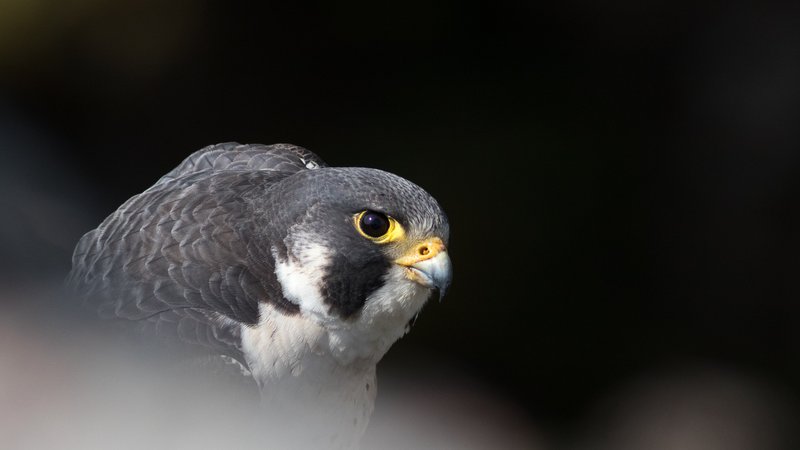
The peregrine falcon is a bird of prey that breeds across the globe. The peregrines breeding in Greenland migrate through North America and overwinter in Latin America. Since the falcons are high up in the food chain, environmental pollutants tend to accumulate in their body. A well-known example is DDT and its degradation products, which cause thinner eggshells in birds of prey – which, in turn, can lead to reduced breeding success and population decline.
This video provides a glimpse of a summer’s fieldwork in South Greenland and provides a summary of key results achieved during 40 years of monitoring and research. Since 1981, Søren Møller and Knud Falk have monitored the breeding success of the Greenlandic peregrine falcons, identified their migration routes and prey selection and - particularly - collected samples to investigate the falcons' content of environmental pollutants. The samples have been analyzed by Katrin Vorkamp and colleagues, and the results have contributed to risk screening of certain new chemical substances that are being added to or considered for the UN list of regulated/banned substances - for the benefit of both falcons and humans. In general, peregrine falcons are doing well in Greenland, but their breeding success varies a lot, depending on the weather from year to year. In the future, larger fluctuations in breeding success are expected, as climate change causes wilder weather and heavier rainfall. Studies in Greenland are important for monitoring global environmental problems - both environmental pollutants and climate effects.
The North Water at Thule in Northwest Greenland is a very special area with large populations of seabirds. Most of Greenland’s thick-billed murre and kittiwake populations breed here as does the majority of the world’s little auk population. The North Water is heavily affected by climate change, and in this video researchers from AU/DCE examine the seabirds together with two local trappers from Siorapaluk. The seabirds are caught gently and equipped with small data loggers. When the birds are recaptured the following year, the data loggers can tell about the migration routes and wintering areas of the birds. Together with other studies, it contributes to our understanding of how the seabirds fare both in the North Water and in their wintering areas, which can be located thousands of kilometres away. Small feather samples are also taken to measure mercury exposure, and food samples are collected from the birds’ diets to follow diet changes as the ecosystem changes. The investigations are carried out in an international collaboration called SEATRACK, where seabirds from colonies throughout the North Atlantic are tracked, and where we e.g. gain knowledge of how the breeding populations from the different countries are mixed in the wintering areas.
In the summer of 2022, we went on a field campaign to the Siggu Nunaa peninsula and visited three different locations. The focus of the fieldwork was to expand existing knowledge of species that had not previously been studied in the area. Consequently, waders and geese were documented and counted, vegetation surveys were carried out, and samples were collected for environmental chemical analyses. The fieldwork was part of the preparation of a regional background study. The purpose of a regional background survey is to make knowledge about nature in an area easily accessible to citizens, mining companies, authorities and politicians. The regional background studies collect existing knowledge from reports and databases, supplement this with new studies and gather local knowledge about nature and how it is used by citizens in the area.